Lake Kutubu - newest Ramsar site in Papua New Guinea
 Papua New Guinea names important new Ramsar site
The Bureau is delighted to announce the designation of Papua New Guineas second Wetland of International Importance, Lake Kutubu (4,924 hectares), the second largest lake in PNG and by all accounts one of the most important recent additions to the Ramsar List. Dr Imo Wari, Secretary of the Department of Environment and Conservation, describes Lake Kutubu as "a freshwater lake in limestone karst country in Papua New Guineas Southern Highlands [at 800m above sea level]. It supports at least 10 endemic fish species, so the new Ramsar Criterion 4 (among others) has been applied in this case. The site boundary matches that of the Lake Kutubu Wildlife Management Area and thus the nomination has the support of indigenous landowners who derive sustainable livelihoods from the wetlands. The site includes approximately 1,000 hectares of swamp forest, a wetland type subject to international concern during the devastating fires in Indonesia last year. The site boundary includes a large part of the lakes catchment, which at present is mostly under cover of upland tropical forest."
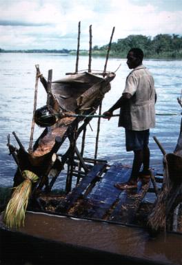 Processing sago, Sepik River, Papua New Guinea (Photo: Roger Jaensch)
The lakes extraordinary level of endemicity (10 of the 14 fish species found there are endemic to the lake itself) exceeds that of any other lake in the entire New Guinea-Australian region. The Ramsar Information Sheet notes that Lake Kutubu was one of the most inaccessible areas in the country, with access only by light aircraft or on foot until recently. The development of oil and gas in the region has increased access with the development of road links and regular flights. Tourism, recreation, education and research, agricultural production and grazing, water supply, and fisheries production have not been developed -- the wetland area is pristine and the potential for such developments is high. All land in the Lake Kutubu catchment is under customary ownership. The RIS, compiled by staff of the WWF-USAs Kikori Integrated Conservation - Development Project, notes that two major cultural/language groups live in the area the Foe, about 2,500 people, live in some 12 villages on the shores of the lake, and the Fasu people are spread widely to the west and southwest of the lake and own the land in which the oil fields are located. The villages around the lake are principally sago subsistence agriculturist, with sago providing 75% of their food volume. There have been several attempts to introduce cash crops, such as cocoa and coffee, but with little success because of limited transportation. With improved transportation, increasing migration into the area may present threats to the ecological character of the site.
The preparations for this site designation benefited from financial assistance from the Ramsar Small Grants Fund and the coordinating efforts of Roger Jaensch, Manager of the Oceania Programme of Wetlands International - Asia Pacific. With the Tonda Wildlife Management Area, PNG's two Ramsar sites now cover 594,924 hectares, and the Convention's 935 sites worldwide cover a surface area of 69,864,955 hectares.