Archaeological evidence for shifting irrigation and cultivation practices at Engaruka, Tanzania
A semi-arid environment is not the obvious place to look for evidence of past wetland agriculture, but this is assuming the environmental conditions have remained the same. In much the same way that wetlands are not static - they are dynamic over both space and time - the same can be said for the past in that although we may see evidence of an old terrace wall, this is likely to have been part of a larger agricultural system that would have varied over both space and time. Teasing out the detail of change over time is where archaeology comes in.
Ongoing archaeological research at Engaruka, Tanzania, one of the largest abandoned agricultural landscapes in East Africa, dating from AD 1400-1800, is demonstrating that whilst the 1,000 hectare site has historically been subjected to intense bimodal rain patterns, the agricultural management systems on the site have adapted and changed.
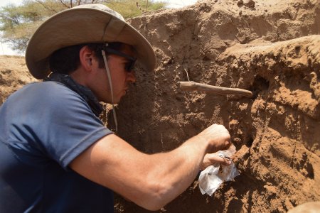
The recent work undertaken at Engaruka as part of the Archaeology of Agricultural Resilience in Eastern Africa (AAREA) project has been using evidence from archaeological stratigraphy, soil micromorphology (thin sections of soil profiles), geochemistry and soil science analyses to look at the historical presence of water, and the sediments within the water. This is providinging a detailed understanding of historic water and soil management.
Dr Daryl Stump, Principal Investigator for the AAREA project explains: “One of the questions we’re interested in is whether the farmers of Engaruka wanted the water and learnt to cope with the sediment loads it carried, or whether the capture of water and sediment was the aim - the latter is seeming most likely.”
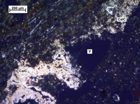
Recent work has analysed the historic accumulations of sediments, some over two metres deep. This has revealed changes over time in the ways in which water was managed for cultivation. Variations within one section show that sediments had been affected in different ways at different times. Waterlogging (enough to grow rice in paddy-like conditions) and seasonal irrigation (wetting and drying of fields) combined with the application of fertiliser application (raising fertility) both show signs that people were actively managing the soil, while avoiding soil salinisation (a known effect of prolonged irrigation). The significance of these results is that even though the method of capturing the sediments (sediment traps) remained the same, the ways in which sediments and water were being actively managed and controlled did not remain the same - they changed over time.
According to Dr Stump: “Archaeology is not restricted to the narrow confines of pure historical interest. This work has revealed more about the extent and the agricultural role of sediment traps than has ever been appreciated by studies of the modern farming system at Engaruka”. As well as revealing new detail about the site, this archaeological information has relevance to contemporary debates concerning the sustainability and resilience of wetland agriculture, particularly with respect to cultivation methods, both past and present.
Dr Suzi Richer, Research Associate, University of York, UK
Suzi’s research concerns the application of archaeological and palaeoecological insights into current issues in environmental and agricultural sustainability. She is part of the European Research Council-funded AAREA project, andhas a background in archaeology, palaeoecology and communications.
Dr Carol Lang, Research Associate, University of York, UK
Carol is the Geoarchaeologist for the AAREA project. Carol’s background is in micromorphological and geochemichal soil analysis, palaeoecology and environmental science.