The “Courtils” of the Marais Vernier Ramsar Site, France: a remarkable landscape heritage
The Marais Vernier (Normandy, France) is a 4,500 hectare marsh located in a former meander of the River Seine, not far from the river mouth. Containing one of the largest peat bogs in France in its southern part, this marsh remains in a natural state, offering a striking contrast with the right bank of the Seine, which is highly industrialised.
A result of co-evolution between nature and humans, the Marais Vernier is an exceptional heritage in terms of its ecology, its landscape and its history, and this has earned the marsh recognition in France itself (nature reserves, regional natural park, etc.), in Europe (Natura 2000) and, since 2015, designation at global level as a Ramsar Site.

One of the main elements of this heritage is the presence of remarkable old plots of land – the “Courtils”, or small gardens, developed in the southern and south-western parts of the marsh and linked to the springs that supply it with water.
Dating from mediaeval times, these plots of land have evolved a great deal over eight centuries, while retaining their typical features relating to the marshland’s edaphic and hydraulic constraints.
It is highly likely that this system has its origins in the Viking invasions of northern France. Support for this is found in place-names: for example the “Chemin de Boël” derives from an Old Norse term “boël”, meaning a long cleared plot of land perpendicular to a main road; and it is located in the Commune of Bouquelon, whose name has similar roots (“Bouquelon” being Old Norse for beech wood).
The term “Courtil” or small garden refers to the fact that some of the strips of peaty land, bordered by small ditches along which spring water is channelled towards the main ditches in the centre of the marsh, were used for subsistence market gardening, producing fruit and vegetable varieties such as the “Sucrin de Honfleur” melon and the Coco du Marais (a type of bean). The peat dug from the ditches was used to raise the level of the land so this cultivation could take place. Most of these plots also continued to be used for grazing livestock, or were mown to produce hay or straw for bedding.
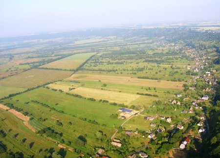
In this semi-circular marsh, the small garden plots converge towards the centre of the marsh without actually reaching it. They range in length from 650 metres in the Commune of Marais Vernier to 1,250 metres in the Commune of Bouquelon.
The great socio-economic changes that have taken place over the last fifty years or so have led to changes in the management of this landscape: market gardening practices have almost disappeared and livestock rearing is hard to maintain, since it is no longer profitable.
The French Coastal Protection Agency (Conservatoire de l’Espace Littoral) and the Boucles de la Seine Regional Natural Park are, however, helping farmers to continue livestock rearing, according to management prescriptions that respect the site’s ecological and heritage value.
The Courtils de Bouquelon Nature Reserve (Réserve Naturelle des Courtils de Bouquelon) contains 70 hectares of “Courtils”, and is a model of eco-friendly management of this wetland, maintaining great value for biodiversity and attracting good numbers of visitors.
By Thierry Lecomte (https://courtilsdebouquelon.wordpress.com/)